| From Small Beginnings |
The Book of MoleseyRowland G. M. Baker, 1986 |
| From Small Beginnings |
'Mighty things from small beginnings grow'
John Dryden, Annus Mirabilis (1666/7)
|
The primary constituent which moulds an individual locality is undoubtedly its relationship to the natural physical domain on which it stands; the fundamental geography which shaped Molesey's destiny and enduring character — and to which we shall return time and time again throughout this narrative — is the water which surrounds it, and from which it is impossible to escape. It was a sub-tropical sea, perhaps some fifty million years ago, which deposited the underlying foundation of thick tenacious clay, the basis of our sub-soil. It was the swirling waters of a mighty river, probably a melting glacier, the last remnants of the time when Britain was shrouded in the frigidity of an ice-age, which precipitated the broad stratum of gravel which overlies the clay, and which, as sand and ballast, is extracted as builder's material today. After the last glacial period, when the retreating ice finally departed this country, the rushing current gradually subsided, leaving the gentler flowing Thames slowly to cut its tortuous course to the sea. It was the Thames and its tributaries, not only the Mole and the Ember, but at one time also innumerable brooks and rivulets that fed into them, which laid down their sediment to form the alluvial, rich and fertile soils, that spread themselves atop the surface of the area. In the gravel and soft soil of the river alluvium are sometimes found the fossilised remains of the creatures which lived here millions of years ago. For instance, when the foundations for the hotel on Tagg's Island were excavated about 1857, some seventeen feet below the surface several specimens were found, including the skull of a long since extinct species of goat, and the jaw bone of a large boar's head. The natural virgin landscape that arose upon this indigenous low-lying structure, devoid of Man's influencing hand, would have been a covering of heavy forest trees, thick alderwood, willow, and the like, interspersed with an entanglement of dense reedy undergrowth, liable at all times to frequent and persistent disgorges of floodwater. Such land formed a redoubtable obstacle to the earliest of our ancestors, much too inhospitable and uninviting for their settlement. The simple folk of primeval times sought instead an open upland terrain where they could scratch away with their primitive wooden implements at the light easily workable soils: a vantage point, readily defensible, with elevated views over the countryside, whereon they might not suddenly be surprised either by intruding enemies or marauding animals, and free from the scourge of disease which could attack either themselves or their flocks in the dank nether region below. Nevertheless, conditions suitable for their choice were to be found not far away on the ridge of sand hills to the south of Molesey, and a string of prehistoric settlements certainly existed upon these hills, on the Warren at Esher, on St George's Hill at Walton, on St Anne's Hill at Chertsey, and on Wimbledon Common. Further to the south of this line of hill forts, and forming a formidable barrier to other settlements, was a broad area of thick clay, marshy and impenetrably wooded. Access to and from these communities, therefore, was virtually only possible on and along the rivers which early man used as his main means of travel. The Thames and the Mole soon emerged as most important factors in communication. In consequence, it is not surprising that all the relics which pre-Iron Age Man left in our area have been dredged from the beds of rivers. The character of these finds, notably not less than three log canoes, hacked out of solid tree trunks, which were sunk in the river bed to be preserved in the mud and brought out for our inspection some two or three thousand years later, is a significant reminder that our earliest visitors were merely travellers along these watery highways, and not permanently settled inhabitants. Other artefacts which have been excavated from the rivers include an axe from the Stone Age and a flint dagger, a spearhead, a looped palstave, and a magnificently embossed shield, from the Bronze Age.
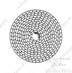
Well-ornamented circular bronze shield from the Bronze Age. The drift away from the old hill forts into the river valleys, which is sometimes referred to as the valleyward movement, started in the late Iron Age, say in the 1st century BC. Probably under the influence of immigrant Belgic tribes, it continued during Roman and Anglo-Saxon times. Its causes were due, first to a much greater sense of security and political stability, and secondly, and more particularly, to higher technical skills, especially the improved iron industry, producing stronger iron axes for the formidable task of clearing the dense woodland, and allowing the development of the heavy wheeled plough with iron share and coulter, enabling the tougher, more fertile, soils of the river valleys thus cleared to be exploited. It is not certain exactly when the area now forming Molesey first became permanently inhabited. Probably, at first land communication in the valleys strayed not too far from the river banks. In the Lower Mole Valley it seems almost certain that a trackway ran close to the river, at least from Cobham to the Thames. Recent excavations adjacent to the Mole, at Southwood Manor Farm at Hersham, prove that a settlement existed there which was occupied during the Iron Age and up to Roman times, and a road broadly following the banks of the river was in use between Hersham and Cobham, until the beginning of the nineteenth century. It was abandoned when new roads were laid out when the commons were enclosed. The earliest occupants of Molesey, therefore, probably established themselves alongside this road, on the slightly rising ground in the wide sweep of the river Mole on which St Mary's Church now stands. (Remember that, even during the disastrous inundation of 1968, St Mary's stood on an island of dry land, environed all round by a sea of flood water). From here they gradually spread out into the surrounding country. There remains no archaeological or historical evidence to prove the rate at which colonisation of the area took place, either during the Iron Age or in the subsequent Roman occupation, or to show continuity with the flourishing community which undoubtedly existed here in Saxon times. The Saxon invaders, as Sir Cyril Fox describes, 'preferred the deep meadow to the hill-pasture; and were probably the first people in Britain to bring order into the marshy alder-choked alluvium of our lowland valley floors' — an apt description of Molesey at that time. This period, then, marked a great step forward, from a people subject entirely to the physical environment in which they dwelt, to one which could at least in some way control its own progress and destiny. The area under occupation soon increased but, because of the ever-encompassing rivers, which were hemmed in by other and more ancient communities, the settlement was not encircled, as most villages are, by waste lands, and once cultivation reached these boundaries, no further expansion was possible. Thus the Moleseys remain to this day as two of the smallest parishes in the whole of Surrey. The earliest documentary evidence relating to this settlement in Molesey stems from the mid-seventh century. At that time the land of Surrey stood amid powerful and contending neighbours, buffeted in turn by one and the other, each grappling for supremacy. Around the year AD 660 it came under the jurisdiction of Wulfhere, son of Penda the great king of Mercia, who installed a vassal ruler, one Frithwald, the only recorded sub-king of Surrey. Wulfhere was the first Mercian monarch to be baptised, and became an ardent protagonist of Christianity. Under his influence, the new religion was implanted in the territory, and the saintly Erkenwald, later to become Bishop of London, was installed as his missionary. About the year 666, 'through love of heavenly glory', Erkenwald founded a monastery for Benedictine monks on a piece of sparsely inhabited land near the Thames at Chertsey, and dedicated it to St Peter. Shortly afterwards, Frithwald endowed it with a grant of much land in north-west Surrey, including Mulesei, with all the 'Fields, Woods, Meadows, Feeding, Rivers, and all other things rightly belonging thereto'. The rents from these lands were to be utilised in the construction and maintenance of the conventual buildings and for the sustenance of the monks. This grant was confirmed in a charter on which Frithwald 'on account of my ignorance of letters' expressed the sign of the holy cross. Chertsey Abbey's lordship over Molesey was thus secured, and by several subsequent ratifications was guaranteed for the next three hundred years and more. From these and later bequests, Chertsey grew to be one of the richest and most powerful abbeys in the whole of southern England. Thereafter, little is heard of the Abbey or its Molesey possessions, until the second half of the ninth century. Then the peace of the countryside was rudely shattered by incursions of ravaging Vikings. In search of plunder they sailed their longships right up the Thames, past London, and on to Chertsey, where they pillaged the monastery of its treasures, set it alight, slaughtered the abbot and ninety of the brethren, and laid the country all around, undoubtedly including the land of Molesey, to waste. Following this devastation and the loss of its productive estates, the monastery suffered a severe setback, and it was not until some fifty years had passed that, in the year 933, King Athelstan refounded the Abbey in a charter issued from the 'royal town called in English Kingston', which confirmed all the old possessions, including the lands at Muleseige, to the 'venerable community of Chertsey as have been constituted and confirmed to that honourable priory by our predecessors from ancient times'. In the ensuing years, a general laxity overtook the Church, and Chertsey, like many other abbeys, was taken over by ordinary priests, who were not bound by rigorous monastic vows. The fabric was allowed to fall into disrepair, and King Edwy diverted at least some of the Abbey's property at Molesey to the Monastery of St Swithin at Winchester. In 964, Edwy's half brother Edgar, who had succeeded him, and was a young monarch passionately attached to the Christian church, was induced by his bishops to expel the priests and replace them with monks, over whom he appointed an abbot to maintain observance of strict monastic rule and discipline. King Edgar also restored to the 'Full and quiet possession of the Abbey' all the land which they had previously owned, including 'twenty mansas in Muleseye which Edwy had unjustly diverted'. However, some time during the following century, and at least by the reign of King Edward the Confessor (1042-1066), Molesey had been divided between four thanes, named respectively Aulric, Toco, Tovi, and Ullward; no records survive to explain why, when, and by whom, the land was taken away from Chertsey Abbey and conferred upon others. The earliest extant document on which the name of Molesey is recorded was in the charter endowing Chertsey Abbey, wherein it is spelled Mulesei, which etymologists suggest is derived from the personal name Mul, compounded with the Old English ey, meaning an island or river meadow — thus Mul's Island. Who, then, was this man Mul who is so remembered? There was a prince, brother of Cadwalla, King of Wessex, with this name, but there seems to be no evidence to connect him with this area and it is unlikely to have been him. The name was pronounced 'mule' and, like that hybrid animal, denoted the offspring of mixed parentage, probably of a Saxon father and a Celtic mother, and was fairly common. Probably the eponymous Mul will never be known. In Domesday Book, the name was Normamsed to Molesham. Mediaeval spellings are usually variations of the original Mulesey, or of Molesey, until about Tudor times, when Moulsey appears. This latter was much used by Victorians, together with the older Molesey, and sometimes both spellings appear in the same document. Gradually Molesey got the upper hand, and was finally adopted by the Post Office as the official spelling. |
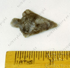
Flint arrowhead, found in the gravel in East Molesey.
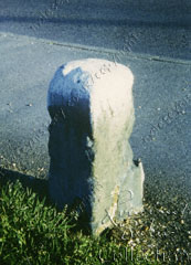
Boundary stone, erected in 1865, between the parishes of East and West Molesey.
|
|
ISBN 0 86023 251 4 The Book of Molesey was originally published by Barracuda Books, now part of Baron, publishers of heritage volumes - maritime, military, transport, sporting and local. It is made available here with the kind agreement of Radmore Birch Associates. Previous ChapterNext ChapterRelated Subjects: Printed version of this book:
A printed copy is available from:
|
All books copyright © R G M Baker, all rights reserved.
Images © 2006 M J Baker and S A Baker, all rights reserved.
Web page design © 2006 M J Baker and S A Baker, all rights reserved.